Facebook

Twitter (X)

Instagram

Somali Magazine - People's Magazine
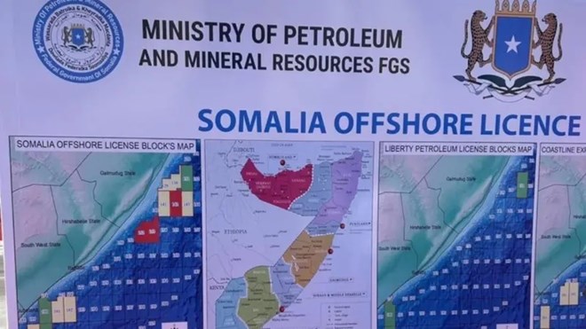
A recent map presented by Somalia’s federal government has sparked a wave of criticism from Puntland and Hirshabelle, two prominent federal states. Revealed at an event in Mogadishu celebrating the arrival of a Turkish oil exploration vessel, the map designated certain areas as “disputed,” a label that Puntland and Hirshabelle officials argue undermines their autonomy and disrupts defined territorial boundaries.
Puntland Response to “Contested” Label
Puntland’s President, Said Abdullahi Deni, quickly denounced the map’s portrayal of Mudug as contested. “Puntland and Galmudug have no disputed boundaries. Our territorial borders are clear, and we maintain a relationship built on mutual respect and peaceful coexistence,” Deni stated. He further emphasized that Puntland’s governance over Mudug is unquestionable, dismissing any suggestion of territorial ambiguity as “an outsider’s misunderstanding.”
Hirshabelle Claims Federal Overreach
Officials from Hirshabelle voiced similar objections, accusing the map of neglecting Somalia’s constitutional provisions, specifically Articles 48 and 49, which define the federal boundaries of member states. “This misrepresentation distorts our state’s integrity and risks promoting divisions,” Hirshabelle representatives stated, condemning the map as potentially harmful to Somalia’s national unity.
Minister Addresses “Technical Oversight” the Puntland and Hirshabelle Issue
In response to the rising tension, Somalia’s Minister of Petroleum and Mineral Resources, Abdirizak Omar Mohamed, explained that the incident was due to a technical mishap. Mohamed noted that an outdated 2015 map, created before Hirshabelle’s formation, was mistakenly displayed by the organizing company. “This was a logistical error, not a political statement. It is disappointing to see minor mistakes used to advance divisive agendas,” Mohamed remarked, encouraging a focus on national progress and unity.
Complex History of Somalia’s Territorial Disputes With Puntland and Hirshabelle

This incident highlights the long-standing challenges Somalia faces regarding territorial delineation, a complex issue since the central government’s collapse in the 1990s. Shifts in governance have led to varying representations of Somali regions, often triggering disputes over borders and jurisdiction. As Somalia navigates its federal future, this episode underscores the urgent need for accurate, up-to-date territorial maps that respect regional autonomy while promoting federal unity.

